my ramblings on cities, planning, transit, maps, politics, chicago, records, soccer, and anything else i damn well please.
31 March 2010
Freeway of Love
Photo: US National Archives
Los Angeles has made the news lately in the world of urban designers and transportation planners with their plan to cap the downtown portion of the Hollywood Freeway with a park. This isn't a new idea, as blogdowntown noted (two years ago!), similar proposals go back at least as far as the mid-80s. Small caps have been constructed in Seattle and Columbus, Ohio, and of course there's the case of Boston's "Big Dig". For more than a decade, Portland has been toying with the idea of various caps on that underused relic of the city's brief Robert Moses fixation, Interstate 405. Seoul has gone them one further and completely removed a freeway, restoring the river beneath and adding some rare green space to the city, and actually improving traffic flows in the area in the process. The chief obstacle has always been cost, LA's plan faces a preliminary price tag of a billion dollars.
I'm not against the idea, rather it makes me wonder how this country ever found the money and political will to build these freeways in the first place. Under the guise of national defense, the Federal-Aid Highway Act of 1956 was passed with little opposition and allocated $25 billion over thirteen years...it wound up costing five times that and going 22 years over schedule. Adjusted for inflation, that would be an initial outlay of nearly $200 billion today. That's a very conservative number, since the price of labor and materials hasn't risen at a level commensurate with inflation and building codes are stricter than they were fifty years ago, especially in earthquake-prone regions. In 1956, the House was split 232-203 (almost identical numbers to today) and the bill passed 388-19...given the state of Congress these days I can just imagine the odds of achieving that same result.
And what did it get us? Five decades of government-subsidized sprawl, urban decay, no real traffic relief and an ever-expanding, ever-aging infrastructure to maintain. I'm not arguing that the country didn't need a federal highway system, but what if it had been done right the first time around? Did we need multiple freeways cutting through every city, or just lines connecting population centers for purposes of commerce and troop deployment? How many congressional districts receive no Interstate highway funding? So far as I can tell, just one: Alaska...though they get plenty of federal money in other forms.
I think the places that have the option of capping freeways got off lucky, even if they can't afford it now. Robert Moses gets a lot of attention (deservedly) for cutting neighborhoods in half via the trench of the Cross-Bronx Expressway, but Richard J. Daley's minions in Chicago's planning department were busy building walls with their freeway money. These elevated roadways placed a physical barrier between the city's expanding African-American neighborhoods on the West and South Sides and the white ethnic neighborhoods across the road. As anybody who's ever walked through a Chicago underpass in winter (or summer, or fall, or...) can attest, they are not the most pleasant pedestrian environments around. These delights serve as de facto homeless shelters, pigeon roosts and garbage dumps. The intersection of Kedzie & Belmont in the Avondale neighborhood is particularly awful. What was once a bustling street corner and intersection of two well-traveled streetcar lines is now entirely in the shadow of the Kennedy Expressway. Belmont Avenue is bisected by 400 feet of railway and freeway viaducts, immediately followed by a large (never-full) parking lot and big box stores. 400 feet is the width of two city blocks east-to-west. I used to live nearby, and found myself annoyed by the state of affairs on pretty much a daily basis.
You can't tell me that this is the best use of valuable urban real estate. This is one small section of interstate in one small section of one city, when you start to think about how many homes, businesses and other neighborhood amenities were destroyed nationwide it's absolutely mind-boggling. Cost aside, it would be political suicide to even suggest such a thing today. So, given all of the reasons above, why are some people still so in love with the idea of building freeways?
Labels:
chicago,
freeways,
planning,
transportation,
urban design
24 March 2010
Addendum...
I found this postcard showing the Walgreens at State & Randolph c. 1960...clearly designed to maximize foot traffic.
via Chuckman's Collection
Labels:
built environment,
chicago,
vintage
The Walking Shopper's Dilemma
Grafton Street, Dublin; Flickr photo by rutty
I don't own a car. Haven't had one for about ten years. My girlfriend does, and we use it for running various errands and trips out of town, but I do the majority of my shopping for groceries and everything else on my bike or on foot. Even in a highly walkable city like Chicago, most of our stores were designed and built with the driving customer in mind, often at the expense of everybody else. The grocery store up the street from our house requires anybody arriving by foot to walk around the end of the security fence into the driveway of the parking lot in order to enter the building...not exactly the safest route.
Richard Layman had a post on urban supermarket design a few months ago that struck a chord with me. He makes the assertion that most grocery and drug store chains don't design their urban stores to take full advantage of their locations. This is something that really bothers me, particularly about Walgreens in Chicago. If you don't live here, they have locations all over the place, and it seems like a new one pops up every couple weeks. The company was one of the pioneers in the use of GIS to target their retail openings, and that is especially evident by the appearance of stores in "food deserts". I don't have any problems with a company using technology to find an underserved market and create a niche for themselves, though it always kind of depresses me when I see people doing their grocery shopping at a drug store with limited food options. But I digress. My problem is with the cookie-cutter store design. They are so ubiquitous that most mid-scale retail development seems to copy their format. Having a basic template is hugely cost-effective in the construction process, but it is impossible to differentiate between a Walgreens store in the neighborhoods of Chicago and one in the outer suburbs (apart from the size of the parking lot).
Yesterday afternoon I was in Wicker Park visiting a friend at his apartment, his front window looks down on the entrance to the Walgreens store at Milwaukee, Wolcott & Wood. (The intersection itself is another problem, and will possibly be the subject of a separate post in the future.) This is an older store, built in the 60s or 70s but the basic problems are the same. First of all is the problem of scale and street frontage. From the end of the parking lot to the furthest corner of the store, the footprint faces 282 feet of Milwaukee Avenue. This may not seem like a great distance, but that's the width of eleven standard Chicago buildings. On the pedestrian level it's basically a dead zone. If you're walking southeast on Milwaukee, first you pass the parking lot, then a long blank wall. Here's a rough model of the site, most other Walgreens I've seen in the city share the same basic alignment with the street:
Again, this is rough, and not precisely to scale, but it's close. You can see how a person walking past is completely out of proportion and would have to walk for some distance before they were engaged. Compound this with the issue of snow and a store like this literally becomes an impediment. In Wicker Park, the Special Service Area maintenance fund pays for snow removal, but in other neighborhoods this entire length of sidewalk would likely remain unshoveled all winter.
The second problem is with the entrance istelf, from a pedestrian view it's just not very inviting. I sat watching people come and go for some time, and I would venture to guess that a full half of the customers did not arrive by car. This is a neighborhood with a very high mode share for walking and cycling and the site use should reflect that. I watched as people bumped into acquaintances, or waited outside in the spring weather while their companion shopped. This is a public space, and should be treated like one. It's unrealistic to call for every Walgreens in the city to be torn down and rebuilt, but with a few minor design changes they could be better urban neighbors and take advantage of increased pedestrian traffic at the same time. Here is another rough model illustrating how getting rid of the Milwaukee driveway (the parking lot would still have an entrance on Wolcott) and losing a whopping four parking spaces, the sidewalk could be widened into a pedestrian plaza.
The result is a much more pleasant streetscape. The store is fundamentally the same, but much more attractive to passers-by. Large windows facing the street on the Milwaukee side could engage pedestrians with tantalizing sale offers, and if somebody sitting on a bench feels like a frosty cold beverage, they could walk across the street to the 7-11, but the path of least resistance is straight into the Walgreens. Of course I couldn't leave out an elotes cart...
Labels:
chicago,
urban design,
wicker park
20 March 2010
London Calling
Most "normal" people, when dreaming of a trip to London, imagine themselves shopping at Harrod's, drinking a few pints in an historic City pub, or perhaps attending a football match at the Emirates. If I've managed to corner you after a couple beers lately, it's altogether likely that I've told you how much I would like to go to London to see the world's largest atlas. The 1660 Klencke Atlas will be on public display for the first time ever at the British Library this summer, and being the huge nerd that I am, I'm pretty much awestruck. I mean, come on. Just look at this thing. All hand-engraved, to boot.
Today, the Independent ran an in-depth preview of the exhibition of which it is a part, titled "Magnificent Maps: Power, Propaganda & Art". It's accompanied by images of several more pieces that will be on display, including the one above, a c. 1917 French map depicting Imperial Germany as a hungry octopus. Wouldn't you just know it, now I want to go see it even more. But alas, London is a rather expensive place to visit, and expenses are something I can't really afford at the moment. So here's hoping I find a job soon to fund a London sojourn, or that some mysterious benefactor sees fit to buy me a plane ticket.
via The Map Room
Labels:
cartography,
london
19 March 2010
On Casinos, Aquifers, Bike Infrastructure, World's Fairs & More: Friday Miscellany
Sick at home today, at least it gives me an opportunity to watch March Madness and get some reading done. I came across a lot of interesting stories today that I'd like to share.
The Chicago Tribune is reporting on the new casino in Des Plaines...this has become a hot issue in Illinois, loads of developers and civic officials (our own esteemed Mayor Daley included) are banking on casinos to bring in missing revenues. They've certainly done a fine job revitalizing (insert sarcasm) East St. Louis and Hammond, Indiana. What really strikes me is that the debate seems to be more about the amount of light emitted by the signs than anything else. Not a single casino in Illinois has fulfilled much of it's initial promise. You only need to look to neighboring Rosemont, where the state gaming commission revoked the operator's license over alleged mob ties...construction had just begun, so far the basement has been completed and that's how it sits. The Des Plaines artists' rendering is telling. Normally, architects and urban designers are keen to show vibrant streetscapes full of happy pedestrian activity...this one doesn't even have sidewalks, just a rather uninspired hotel tower (reminds me of the ones they've been busy tearing down at Cabrini-Green) next to a very wide street with unrealistic traffic projections.
Echoes of my remote sensing class in college: Der Spiegel reports on a team of German geologists searching for untapped aquifers in Saudi Arabia. The Kingdom's water supply is in such dire circumstances that the government has ended wheat subsidies and ordered all domestic wheat production to cease by 2016.
Dublin City is considering adding contraflow cycle zones. If you're not familiar, contraflow basically translates to a street which is one-way to motorized traffic and used in both directions by cyclists. These are provided to channel cyclists away from heavy traffic areas and are common in cities with a high cycling mode share like Amsterdam. A typical anti-cyclist bias exists on the council though, characterized by the member noting that 97% of commuters are not using bikes. Experience in Denmark and the Netherlands clearly shows that when you improve the infrastructure, you attract more bicycles, not the other way around.
Steve Offutt & Matt Johnson of Greater Greater Washington have posted an excellent four-part series about the transit problems faced by that most edgy of edge cities, Tysons Corner, Virginia (here's part one). I've never visited, and it sounds like I won't want to for another forty years or so. The problems are the same as in exurbs around the country, lack of pedestrian infrastructure, no neighborhood cohesion and long travel distances. DC Metro is currently building a new line to Dulles Airport through here, but the stations are too far from most of the employment centers to entice many workers to leave their cars at home. GGW gives us a few possibilities to improve the planned bus circulator service.
A long-time obsession has been reignited...
Thanks to my old pal Kevin Chan, I have a new obsession as well: a website called OpenFlights. Maps + airlines + travel bragging? It's practically custom-built to appeal to my nerdiness. I've scanned my memory banks and I think I managed to get most of the flights I've been on in my life up there. I like the way the maps look, it reminds me of Kevin Lynch's nodes & paths. And speaking of Kevin Chan, I've got some serious traveling to do if I ever want to catch up to his map.
And finally! I just couldn't leave this out...Inhabitat is spotlighting a cardboard 45 sleeve that can be turned into a portable turntable. I'm sure the sound quality is horrid, but it's still pretty cool.
17 March 2010
Designing Streets as Public Places in Cold Climates
I'm reposting a video of a hugely interesting presentation given last month by Kristian Villadsen of Gehl Architects at McGill University in Montreal. Mr. Villadsen makes a number of important points about designing streets on a scale for pedestrians, creating beneficial microclimates, giving priority to bike lanes for snow removal, and cultivating a year-round "culture of public life". He brings numerous examples from Copenhagen, as well as Beijing, Sweden, New York City & even Greenland. Hopefully, Chicago's planners are taking copious notes.
via copenhagenize
Labels:
copenhagen,
planning,
urban design,
winter
16 March 2010
Detroit: City on the Move
I was perusing the Prelinger Archives a few months ago and came across this promotional film produced by the Jam Handy Organization for the City of Detroit in 1965...two years before the riots from which the city has yet to recover. It's quite striking to contrast the rosy boosterism and faith in the future of the city's "automotive genius" with the reality on the ground today. It's especially exciting to see footage of urban planners IN ACTION!!! Thrill, as a guy points at a land use map! Swoon, as a different guy puts an architectural model onto a table! The narration is very dry, but it's a fascinating historical document nonetheless.
15 March 2010
Red de Metro
Webdesigner Depot has posted a plethora of official Metro maps from around the globe. They're really quite fascinating to look at side-by-side. Chicago doesn't look so bad compared with other world cities (take a look at Miami's single line, for instance), but a far cry from a Moscow or a Seoul.
This sort of map is interesting to me because I think it really shows the priorities of a place. Compare Atlanta with Barcelona...cities with similarly-sized metropolitan populations, and each a former Olympic host. The similarities end there, once you see how much more extensive Barcelona's system is. Atlanta's map, and many of the other American examples, put a great emphasis on showing us where riders can park their cars and the only roads shown are freeways. Now look at Barcelona's red...you'll see the funicular railway, the cable car, the ferry terminal, a couple dozen transfer points...but not a single park & ride. A resident of Barcelona would probably find it quite strange to drive one's car to get to the subway, but then again, there's likely a station within a couple hundred meters of their front door.
via the map room
11 March 2010
And so it begins...
Image: Michael Spry, all rights reserved
I have been effectively cajoled into starting a blog, wherein I shall regale you all with my views on all the things that I hold dear. These will include, but will not be limited to, urban planning, transit issues, community development, cartography and the like. I shall do my best to keep things on topic, but please do not be surprised when I go off into long, rambling tangents on soccer, soul 45s, vintage airline ephemera or the Portland Trailblazers.
About the name of this blog...it is a reference to a song from the Jam's 1982 album, "The Gift" titled "The Planner's Dream Goes Wrong" (you can watch a fan-made video for it here). So often, those in the planning profession presume to know what is best for society, since after all, we are the ones who have devoted our lives to learning the ins-and-outs of building codes and land-use ordinances.
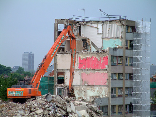
In the 1960s, the wave of urban renewal hit the United Kingdom, moving tens of thousands of working class Britons out of 2-up-2-down rowhouses into brutalist, Corbusier-inspired tower estates. The country suffered a severe recession in the 1970s, leading to government cutbacks on maintenance and security. By the end of that decade they had become rather dreary places to live, leading the Jam's Paul Weller to write, "They were gonna build communities-it was going to be pie in the sky; But the piss stenched hallways and broken down lifts say the planner's dream went wrong".
It is easy for us to assume what people need, because all too often we are not the ones who need to live with the results. I firmly believe that planners can play an important, beneficial role, but only if they are able to put aside their preconceptions and listen to the community. And so I have given a blog which will generally have an optimistic tone a pretty grim name...to remind us that what may seem like a great idea today may have unforeseen consequences.
Subscribe to:
Posts (Atom)